Methi Ekasingh, Sureeporn Soodchalee, Panomsak Promburom, and Taweesak Vearasilp
![]()
Methi Ekasingh, Sureeporn Soodchalee, Panomsak Promburom,
and Taweesak Vearasilp
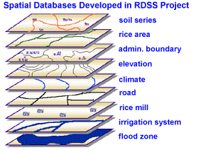
Many spatial data layers are required in the RDSS
Project (Fig.1). Among them, soil data is
considered to be a significant input for the rice model. In this project, soil
spatial data are also overlaid with the climatic data layer to form simulation mapping
unit (SMU) within which rice yield will be simulated.
Figure 1 Spatial Databases Developed in RDSS Project
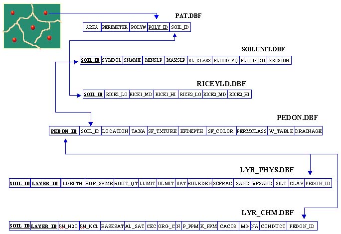
A spatial database was designed to store and mange soil data at the series level. The spatial data are stored as Arc/INFO coverages, the attribute tables of which are linked to relational tables which store data for each horizon of all soil pedons found in Chiang Mai and Pitsanulok provinces. A structure of soil database is shown in Fig.2. It is flexible to allow for making a query on specific soil characteristics as shown in Fig.3 and it can be transformed and exported as an soil input data file for CERES-Rice made as in Table 4.
Figure 2 Structure of Soil Database
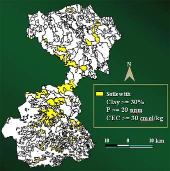
Figure 3 Soil Database Query Result, Soil series in 2 Amphoe in Pitsanulok Province.
Table 1. Soil Series Attribute Data for each SMU
| * Soil Input File ! Prepared by Panomsak Promburom *CMCM980102 MCCDLD -99 107 Fine sandy clay loam @SITE COUNTRY LAT LONG SCS_FAMILY MCC_CMU Thailand 18.80 98.90 @ SCOM SALB SLU1 SLDR SLRO SLNF SLPF SMHB SMPX SMKE -99 0.13 9.8 0.05 84.00 1.00 1.00 SA008 SA003 -99 @ SLB SLMH SLLL SDUL SSAT SRGF SSKS SBDM SLOC SLCL SLSI SLCF SLNI SLHW SLHB SCEC 16 Apg 0.090 0.220 0.425 0.850 0.5 1.50 1.06 13.0 45.0 0.0 -99 5.8 4.8 62.0 26 B12tg 0.170 0.280 0.425 0.660 0.2 1.50 0.00 30.0 33.0 0.0 -99 7.7 6.1 11.0 44 B22tg 0.170 0.280 0.425 0.500 0.2 1.50 0.00 27.5 33.5 0.0 -99 7.8 6.3 12.0 107 B23tg 0.170 0.280 0.425 0.220 0.2 1.50 0.00 30.5 32.5 0.0 -99 8.4 6.8 10.0 |
For more information please contact: methi@chiangmai.ac.th